Sub-annual to multi-decadal shoreline variability from publicly available satellite imagery
Abstract
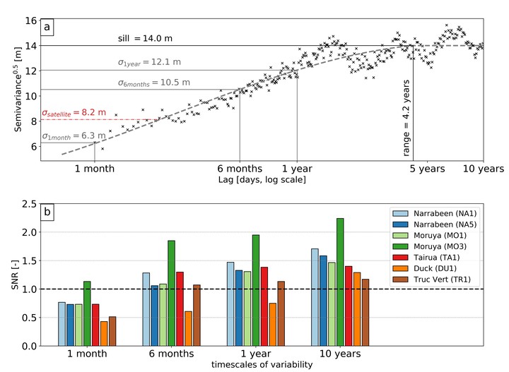
The ability to repeatedly observe and quantify the changing position of the shoreline is key to present-day coastal management and future coastal planning. This study evaluates the capability of satellite remote sensing to resolve at differing temporal scales the variability and trends in shoreline position along sandy coastlines. Shorelines are extracted from 30 + years of publicly available satellite imagery and compared to long-term in-situ measurements at 5 diverse test sites in Europe, Australia, the USA and New Zealand. These sites span a range of different beach characteristics including wave energy and tide range as well as timescales of observed shoreline variability, from strongly seasonal (e.g., Truc Vert, France), to storm-dominated (e.g., Narrabeen-Collaroy, Australia), to only minor annual to multi-annual signals (e.g., Duck, USA). For the 5 sites, the observed typical horizontal errors varied between a root-mean-squared error (RMSE) of 7.3 m and 12.7 m. An analysis of the typical magnitudes of shoreline variability at temporal scales ranging from a single month up to 10 years indicates that, by the implementation of targeted image pre-processing then the application of a robust sub-pixel shoreline extraction technique, the resulting satellite-derived shorelines are generally able to resolve (signal-to-noise ratio > 1) the observed shoreline variance at timescales of 6 months and longer. The only exception to this is along coastlines where minimal annual to multi-annual shoreline variability occurs (e.g. Duck, USA); at these sites decadal-scale variations are successfully captured. The results of this analysis demonstrate that satellite-derived shorelines spanning the past 30 years as well as into the future can be used to explore and quantify intra- and inter-annual shoreline behaviour at a wide range of beaches around the world. Moreover, it is demonstrated that present-day satellite observations are also capable of capturing event-scale shoreline changes (e.g. individual storms) that occur at timescales shorter than 6 months, where this rapid response exceeds the typical magnitude of shoreline variability. Finally, several practical coastal engineering applications are presented, demonstrating the use of freely-available satellite imagery to monitor inter-annual embayed beach rotation, rapid storm-induced shoreline retreat and a major sand nourishment.
Kilian Vos
Earth Observation Scientist
Research interests include Earth Observation, machine learning, coastal and water resources engineering.